|
Qualified Person
Christopher Naas, P.Geo, of CME Consultants Inc., is the Qualified Person under the meaning of NI 43-101, who prepared, supervised the preparation of, or approved of the technical information being disclosed in this website. He is not independent of the Company.
Click here to download:
The Galaxy 43-101 Technical Report 2013 
Project and Ownership
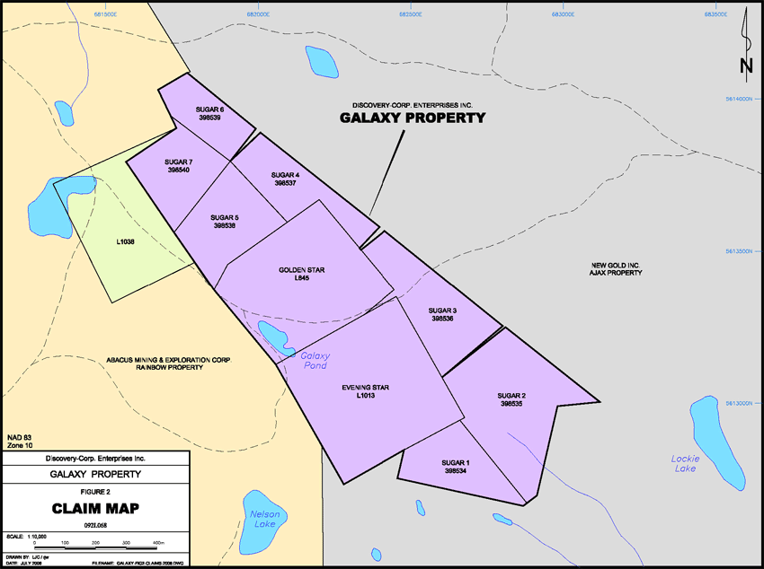
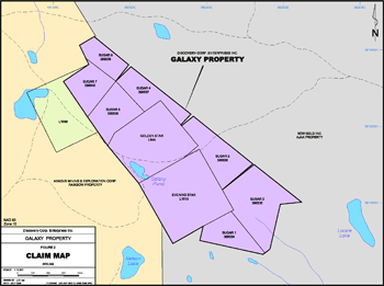 The Galaxy property is comprised of nine claims, two Crown granted claims (Golden Star and Evening Star) and seven mineral claims (Sugar 1 through 7), covering approximately 91 hectares, seven kilometres southwest of the city of Kamloops in south-central British Columbia within the Kamloops Mining District. The project is located approximately seven kilometres southeast of the past-producing Afton mine and four kilometres northwest of the former Ajax mine.
All of the claims and the under-surface rights on the Crown grants are 100% owned by Discovery-Corp. The seven mineral claims are in good standing. The two Crown granted claims are in good standing and are renewed annually. There are no outstanding royalties payable on the property.
The Galaxy property is centred 2.5 kilometres south of the Trans Canada Highway and approximately 4.5 kilometres east of the Coquihalla Highway. From Kamloops, follow the Lac Le Jeune road for approximately 5.5 kilometres from its intersection with Copperhead Drive. Just south of Wallender Lake, a dirt road heads northwest from the Lac Le Jeune road for approximately 2.5 kilometres to the Galaxy property.
The property is located within the Kamloops city limits and approximately seven kilometres southwest of the city centre. Local infrastructure is very good with the two major highways in close proximity and the Canadian Pacific Railway located approximately five kilometres north of the property. The Afton area has a long history of mining and exploration and all necessary services, including a full-service airport, are available in Kamloops.
The property covers gently rolling hills, typical of the area, with elevation ranges across the property of approximately 915 metres to 975 metres. A thick layer of glacial till commonly exceeding 10 metres covers the Galaxy property and rock exposure is limited, with less than 5% outcrop on average. Vegetation consists of open, mixed Douglas fir and ponderosa pine forest with grassy undergrowth and open areas with sagebrush and bunchgrass. A small ephemeral pond, the Galaxy pond, is located immediately west of the Galaxy zone. Seasonally and by permit only, limited water is available for drilling from the pond. Hauling or pumping in water would be necessary if significant water volumes were required for exploration or mining purposes.
The climate in the area is semi-arid, with hot summers, little rainfall and with temperatures typically exceeding 30 degrees Celsius during summer months. Winters are relatively mild with little snowfall and with average temperatures just below freezing. Although winter may last from mid to late November through to early April, exploration is possible year round.
Regional Geology
The Galaxy property is situated within the Quesnel Terrane. The oldest rocks in the area belong to the Devonian to Permian Harper Ranch Group, which consists of two members, a lower volcanic arc succession and an upper carbonate platformal succession, and forms the basement to the Quesnel Terrane in this area. Overlying the rocks of the Harper Ranch Group is the Late Triassic Nicola Group, a thick subaqueous island arc assemblage that forms a belt approximately 25 kilometres wide and as much as 7.5 kilometres thick. The Nicola Group consists mainly of fine-grained and porphyritic volcanics of dominantly andesitic composition and of tuffs and breccias. Minor sediments are associated with the volcanics, including limestone, argillite and conglomerate. In the Iron Mask area the Nicola Group is separated into eight distinct units. One of these units is a serpentinized basalt known locally as picrite, which is intimately associated with many of the known mineral deposits. The picrite has been interpreted to represent wedges of basalt that have been tectonically emplaced along major fault zones.
The Nicola rocks are intruded by the Late Triassic Iron Mask batholith, a northwest-trending body comprised of two separate plutons, the southern Iron Mask pluton (22 kilometres long by 3 to 5 kilometres wide) and the Cherry Creek pluton to the northwest (5 kilometres by 5 kilometres). The Iron Mask batholith is host to a number of important alkalic copper-gold porphyry style deposits.
While most of the mineralization is hosted within the Iron Mask batholith, near the contact with the batholith the Nicola rocks may be foliated and may also contain copper mineralization.
The Iron Mask batholith is subdivided into four phases: the Sugarloaf, Cherry Creek, Pothook and Hybrid. Saussuritized feldspars and widespread propylitic alteration are common within the Iron Mask batholith. Albite alteration occurs in highly fractured zones in all phases of the intrusion. Similarly, K-spar alteration occurs locally in all phases but is most widespread in the Cherry Creek phase as a result of its higher primary potassic content. Copper-gold mineralization is most often associated with the Cherry Creek and Sugarloaf phases of the intrusion and with contacts between these phases and the Pothook or Hybrid phases. The mineralization is typically associated with albite and/or K-spar alteration.
Structurally, the Iron Mask batholith is dominated by northwest-trending, high and moderate-angle faults that have been interpreted as major deep seated structures that controlled deposition of the Nicola Group rocks and emplacement of the batholith. Most of the deposits discovered to date are located within these favourable structural corridors, one of which passes through the Galaxy property and hosts known mineralization at the Galaxy zone.
Property Geology
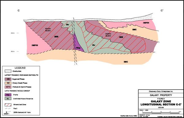
The Galaxy property is situated in the northeastern portion of the Iron Mask batholith along the favourable Iron Mask-Galaxy structural corridor. A northwest trending band of picrite occurs along the western property boundary and marks the position of a major steeply dipping, northwest trending fault. West of the fault, the Cherry Creek phase is exposed while to the east, Nicola volcanics, Sugarloaf and Hybrid phases occur above a zone of highly foliated, red (hematitic) mylonite several feet thick. The mylonite occurs along a low-angle west dipping fault that is believed to be part of the Cherry Creek thrust. Albitized Cherry Creek monzodiorite, with typical hypabyssal textures, occurs at depth in the footwall of the thrust/mylonite zone as well as on surface, east of the surface trace of the thrust fault. The Cherry Creek phase in the vicinity of the Galaxy zone is medium to fine-grained, pinkish-grey, quartz-bearing porphyritic rock with widespread strong albite alteration. The altered rock is buff to light grey in colour with a pinkish cast and may contain veinlets of quartz and carbonate. Both K-spar and mafic minerals are typically absent. Fractures and slip planes are typically hematitic.
Mineralization
Alakalic copper-gold porphyry style mineralization is well known within the Iron Mask batholith. Since the late 1970s, four deposits (Afton, Ajax, Pothook and Crescent) have been mined, all by open pit methods with all ore being processed in the Afton mill. Recent exploration has delineated a number of other deposits, including a higher-grade underground bulk-mineable resource at the New Afton mine. Considerable exploration and research in the area has resulted in a well-defined deposit model that includes both medium to large, low to medium grade, near-surface open-pittable mineralization, such as Afton and Ajax, and small to large, medium to high-grade, underground bulk-mineable mineralization such as the New Afton deposit.
Although mineralization can occur in all phases of the Iron Mask intrusion, all of the significant mineralization discovered to date has been hosted within the Cherry Creek and Sugarloaf phases where they are in contact with the older phases of the intrusion. Mineralization consists of fracture-controlled chalcopyrite and lesser bornite with association magnetite and with peripheral pyrite and pyrrhotite. Gold is associated with copper mineralization and minor molybdenite is common on fractures. Palladium and silver are important in some of the deposits. Higher-grade mineralization typically occurs in fault and hydrothermal breccias and often in pipe-like bodies. Supergene alteration may occur, such as at the Afton deposit where much of the deposit was within a supergene alteration zone that contained significant native copper and lesser chalcocite.
Several favourable structural corridors (the Leemac, Afton and Iron Mask-Galaxy) are recognized within the Iron Mask batholith. The structural corridors are zones of brittle deformation up to 500 metres in width and often contain slices of picrite or of Nicola volcanics. All of the important known deposits in the Iron Mask batholith occur within a favourable structural corridor. Discovery-Corp.'s Galaxy property is well situated along the Iron Mask-Galaxy structural corridor.
Mineralization in the Galaxy zone occurs in the hangingwall of the thrust/mylonite zone within the Sugarloaf phase and within Nicola volcanics. The area is structurally complex, with several steep faults that postdate the thrust fault and the mineralization.
Alteration
Alteration assemblages vary in the different deposits; however mineralization is always associated with alteration. The mineralizing event is pre-dated by an intense albite alteration event that appears to be an important control for later faulting and thus for focussing mineralizing fluids. Typically a broad zone of propylitic alteration encompasses areas of mineralization and potassic alteration is common in all deposits that are characterized by pyrite, chlorite and epidote, while potassic alteration involves the replacement of plagioclase by K-spar.
Galaxy Zone
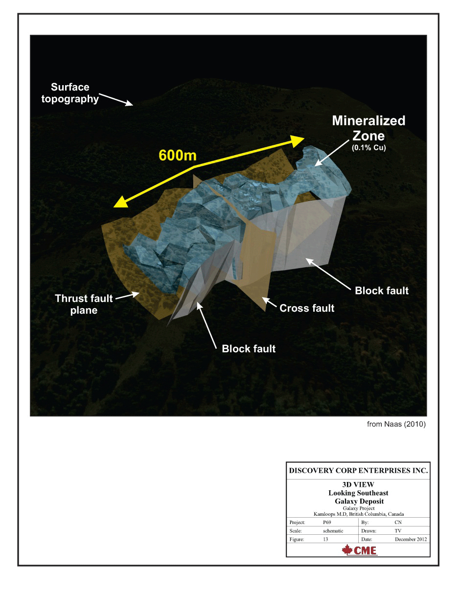
The Galaxy zone is located entirely on the Golden Star and Evening Star claims. The only known mineralization on the Galaxy property is the Galaxy zone, situated just east of Galaxy pond. The Galaxy zone is an elongate, northwest trending fault-bounded zone of mineralization hosted within Nicola volcanics and Sugarloaf diorite measuring approximately 345 metres in length by 120 metres in width. The mineralization is indicated by drilling to be up to 600 metres long and a maximum of 140 metres in depth. It is comprised of two discrete sections of mineralization referred to as the South Block and North Block. Mineralization is truncated at depth by a low-angle, west-southwest dipping thrust fault that surfaces approximately 90 metres east of the Evening Star shaft forming the eastern boundary of the deposit. A northwest-trending zone of picrite marks the position of a major steeply-dipping, northwest trending fault and defines the western faulted contact of the deposit.
Sulphide mineralization within the Galaxy zone consists primarily of pyrite, chalcopyrite and pyrrhotite, as fracture fillings and hairline to centimetre-scale veinlets and as fine disseminations adjacent to fractures. Massive to semi-massive sulphide veins, locally exceeding one metre in width, occur within the mineralized zone. Pyrite and chalcopyrite also occur as blebs in orthoclase-albite-epidote veins with albitized and/or propylitic alteration envelopes within intensely sheared zones. In general, mineralization appears to be best developed near the intersection of northwest and northeast fault zones.
Previous Exploration
Work on the Galaxy property dates back to the late 1890s with the discovery of mineralization on the Evening Star claim, at what is now known as the Galaxy zone. Considerable exploration and development work was carried out property in the early 1900s, particularly on the Evening Star claim including two open cuts, two short shafts, a short tunnel as well as several shallow pits and trenches dug on the Evening Star and Golden Star claims.
Through to 1917, various operators continued to explore the Galaxy property and carried out a considerable amount of prospecting and diamond drilling. A total of 48 tonnes of ore was shipped from the Evening Star mine with average grades of 5.3% copper and 18.8 grams of silver per tonne. No further work is documented on the Galaxy property until 1956 when it was acquired by Galaxy Minerals Ltd.
Following is a table showing the work carried out on the Galaxy property from 1956 through to 2000.
| Year |
Company |
Work Program |
| 1956-64 |
Galaxy Minerals Ltd |
- Rehabilitated the Evening Star shaft.
- Carried out underground sampling, trenching, road work, Induced polarization survey and diamond drilling (38 holes totalling 5,225 metres) at the Galaxy zone.
- Changed name to Galaxy Copper Ltd.
|
| 1965-66 |
Vanco Explorations |
- Geophysical and geochemical surveys, diamond drilling on the Galaxy zone (24 holes totalling 2,418 metres).
|
| 1968-71 |
United Bata Resources Ltd./Kimberly Copper Mines Ltd. |
- Rehabilitated Evening Star shaft and completed a total of 122 metres of underground drifting from the shaft at the 80 foot level.
- 16 surface diamond drill holes totalling 1,562 metres were drilled at the Galaxy zone.
- Estimated resource of approximately 3.6 million tons of proven and 1.8 million tons of indicated with an average grade of 0.58% copper.
This resource estimate cannot verified, therefore should not be relied on, and is reported only for historical interest.
|
| 1971 |
Nor-West Kim Resources Ltd. (formerly Kimberly Copper Mines Ltd.) |
- Surveyed and mapped the underground workings on the Evening Star claim.
- Extended the northwest drift from shaft at the 80 foot level to a point 365 metres northwest; put a 30 metre ventilation raise to surface.
- Collected two bulk samples.
- Carried out 1,333 metres of surface drilling and 327 metres of underground diamond drilling on the Evening Star claim.
|
| 1973 |
Teck Corporation Ltd. |
- Completed an induced polarization survey on the Makaoo property, which included the Galaxy property.
- Defined possible northwest trending chargeability anomaly east of the Galaxy zone.
|
| 1976-77 |
Canadian Superior Exploration |
- Carried out geological mapping, topographic and ground magnetometer surveys.
- Drilled 8 percussion holes totalling 731 metres.
|
| 1985-87 |
Abermin Corporation |
- Drilled 7 percussion drill holes totalling 367 metres, four of which were on the Galaxy property, and tested the Galaxy zone.
- Reported a resource of approximately 2.27 million tonnes grading 0.6% copper and 0.51 grams of gold per tonne for the Galaxy zone. This resource estimate cannot verified, therefore should not be relied on, and is reported only for historical interest.
|
| 1990 |
Getchell Resource Corp. |
- Completed percussion drilling at the Galaxy zone to verify earlier drill results and evaluate the gold potential of the zone.
- 7 holes totalling 649 metres were drilled and a historical resource of 3.2 million tonnes grading 0.65% copper and 0.34 grams of gold per tonne was estimated for the Galaxy zone.This resource estimate cannot verified, therefore should not be relied on, and is reported only for historical interest.
|
| 1995-96 |
Getchell Resource Corp./Afton Mining Limited |
- Under contract to Afton Mining, Teck Explorations completed delineation drilling on the Galaxy zone consisting of 33 diamond drill holes totalling 4,087 metres.
- A resource for the Galaxy zone was estimated of 1.7 million tonnes grading 0.39% copper and 0.13 grams of gold per tonne with a high-grade of 862,000 tonnes grading 0.65% copper and 0.22 grams of gold per tonne, significantly lower than earlier estimates.This resource estimate cannot verified, therefore should not be relied on, and is reported only for historical interest.
|
| 2000 |
Getchell Resource Corp. |
- Getchell Resource Corp. was renamed Discovery-Corp Enterprises Inc.
|
Between 1972 and 1999, approximately $500,000 was spent on previous exploration of the Galaxy property.
Company Exploration
Discovery-Corp acquired the Galaxy property in 1990, when the Company was known as Getchell Resources Corp., and carried out considerable work on the Galaxy zone (see above Previous Exploration).
Exploration since then has consisted of diamond drilling, mapping, rock sampling, geochemical and geophysical surveys, data compilation and deposit modelling.
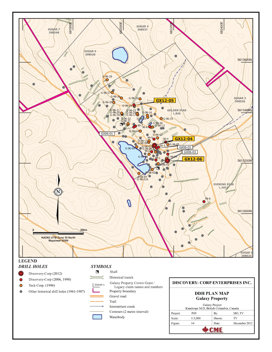
Diamond drilling was undertaken in 2006. Three drill holes totalling 285 metres were completed in the Galaxy deposit area. Significant copper and gold results from these drilling programs are presented in the table below
| Hole |
Interval (m) |
Results |
| From |
To |
Length |
Cu (%) |
Au (g/t) |
| GX06-01 |
23.47 |
53.65 |
30.18 |
0.39 |
0.20 |
| incl |
23.47 |
26.12 |
2.65 |
2.47 |
1.34 |
| GX06-02 |
3.66 |
73.90 |
70.24 |
0.32 |
0.07 |
| incl |
13.50 |
19.50 |
6.00 |
0.66 |
0.07 |
| and |
35.35 |
38.40 |
3.05 |
1.43 |
0.30 |
| GX06-03 |
5.75 |
94.70 |
88.95 |
0.31 |
0.08 |
| incl |
11.75 |
17.75 |
6.00 |
0.60 |
0.08 |
| and |
63.60 |
76.30 |
12.70 |
0.60 |
0.08 |
Rock sampling has identified anomalous copper and gold values were returned from several samples, including 0.66% Cu and 2.22 g/t Au from an old trench at the northern end of the deposit. Several hundred metres northwest, an area of altered diorite with malachite staining was discovered in subcrop.
Several hundred metres southeast of the Galaxy zone a northeast trending zone of copper mineralization appears to be intermittently exposed over a strike length of approximately 85 metres and is open on strike in both directions. A representative collection of chips from the dump of an old pit testing the mineralized zone returned values of 0.52% Cu and 0.11 g/t Au. Three continuous chip samples across the zone returned an average grade of 0.29% Cu and 0.13 g/t Au) over 24 metres.
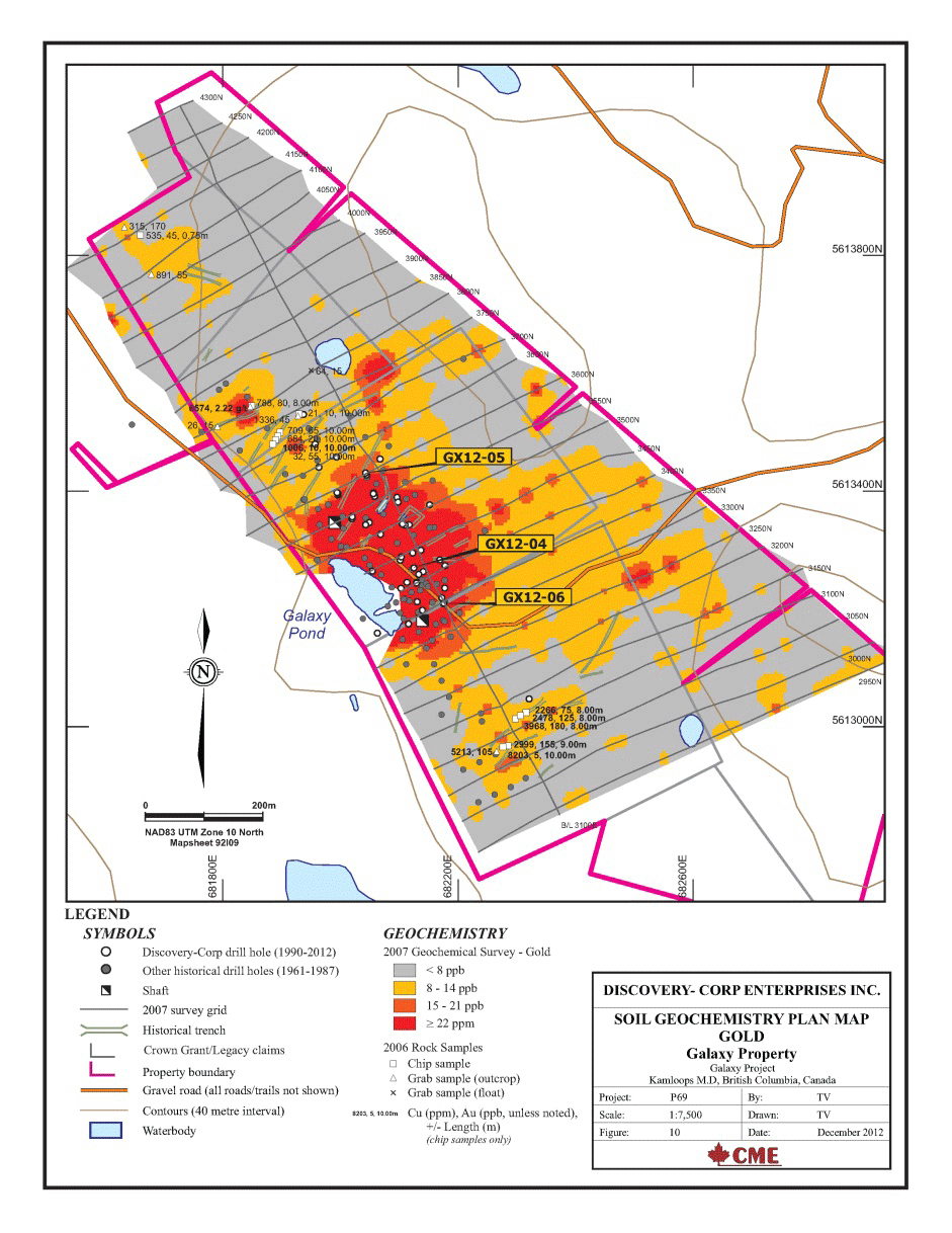
Soil sampling confirmed a strong, 300 metre long by 150 metre wide coincident Cu-Au soil anomaly over the Galaxy deposit. Additional coincident Cu-Au soil anomalies were defined by the soil survey, beyond the limits of the deposit. These soil anomalies occur in areas of thick till cover with minimal rock exposure and are less extensive and less well-defined than the Galaxy deposit anomaly. To the northwest of the Galaxy deposit, a Cu-Au soil anomaly occurs on-strike with the trend of the known mineralization. Several old cat trenches and very limited historic drilling has been done in this area. Approximately 150 to 200 metres east of this, a second Cu-Au anomaly occurs, in an area with no outcrop or previous work.
South-southeast and on-strike with the Galaxy deposit, a Cu-Au soil anomaly was defined in the vicinity of known mineralization on the Evening Star crown grant. Limited historic drilling has been done in this area.
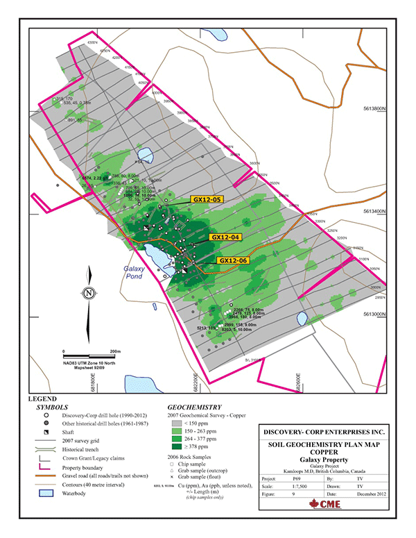
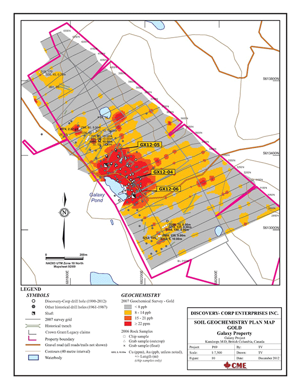
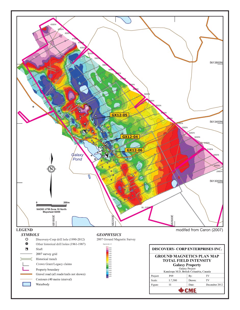
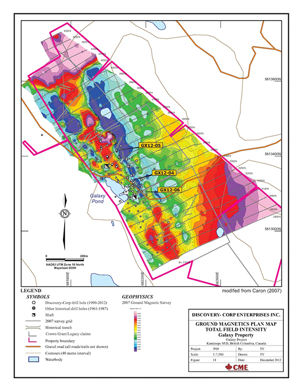
A ground magnetometer survey was carried out to define the magnetic signature in the area of known mineralization and to test for other areas of similar magnetic signature elsewhere on the Property. The Galaxy zone is associated with a northwest trending magnetic high anomaly, and with flanking magnetic low anomalies on the eastern and western margins of the mag high. This magnetic signature continues on-strike to the northwest for 400 metres beyond the limit of the known Galaxy zone. The northwestern Cu-Au soil anomaly occurs along this magnetic trend. To the southeast of the Galaxy zone, the northwest trending mag high/flanking mag low magnetic signature continues, but is less well defined. The central mag high feature broadens to the south, with the flanking eastern and western mag lows become less pronounced (or in the case of the western mag low, less well defined by the survey due to the proximity to the survey boundary). Both the southern and the east-southeastern soil anomalies are associated with this southern, less well defined, portion of the mag high/low feature
In 2009, the Company undertook a compilation program of the existing data to prepare a conceptual model of the deposit to guide further exploration. Wireframes of the mineralization and key structural features were developed using all known drill hole data.
The wireframe of the mineralization, based on a grade of 0.1% Cu, covers approximately 600 metres of strike length, with a maximum depth of approximately 140 metres.

Additional drilling was undertaken in 2012 as a means to test the model, improve geological understanding and increase the geochemical database. Three drill holes totalling 306 metres were completed in the Galaxy deposit area. Significant copper and gold results from these drilling programs are presented in the table below.
| Hole |
Interval (m) |
Results |
| From |
To |
Length |
Cu (%) |
Au (g/t) |
| GX12-04 |
42.62 |
76.25 |
33.63 |
0.46 |
0.13 |
| incl |
42.62 |
50.70 |
8.08 |
1.07 |
0.30 |
| incl |
45.70 |
47.70 |
2.00 |
2.18 |
0.65 |
| GX12-05 |
69.06 |
117.34 |
48.28 |
0.61 |
0.14 |
| incl |
90.06 |
101.06 |
11.00 |
1.07 |
0.21 |
| and |
106.06 |
107.06 |
1.00 |
2.72 |
0.49 |
| GX12-06 |
6.50 |
39.28 |
32.78 |
0.44 |
0.11 |
| incl |
7.62 |
22.14 |
14.52 |
0.62 |
0.124 |

To date, Discovery-Corp, including its former joint venture partner, Teck has expended approximately $400,000 on exploration of the Galaxy property.
Mineral Resources
Discovery-Corp believes the resource potential of the Galaxy property is significant and intends to conduct further exploration to establish a NI 43-101 compliant resource estimate.
|